

Google Maps is one of those applications that every user should have on their mobile. It allows you to consult maps, but also to locate traffic lights, how much you will spend paying tolls, the best routes for electric cars and a lot of other information.
However, for Google all these things are not enough and therefore they continue to develop new features for their navigation app. The last thing they came up with is fantastic, as Google Maps added aerial views and improved its cycling routes in one of its latest updates.
Cycle routes are now much more detailed on Google Maps
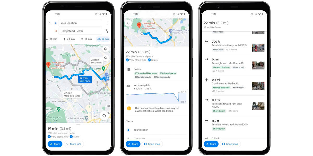
Although Maps has been able to show directions and routes for cyclists for many years, the information offered was quite brief. This will no longer be the case, since Google Maps has just improved this functionality by adding many new features, including:
- Detailed summaries of the routes, being able to choose between those with more bike lanes or another with fewer turns .
- A section that tells you, through a graph, the highest or lowest points of the route you chose. In addition, it tells you when you will find very steep hills .
- Route information will now accurately tell you how many lanes you will have on bike lanes, shared paths, major and minor roads.
- It will also tell you if there are stairs in any section of your route.
And if all this were not enough, Maps will also allow you to see a detailed breakdown of the route itself. Now you will be able to take a look at different sections of the route through photographs, which will help you to know what awaits you later.
Why is Google doing this now and not before? In that sense, the company was really transparent in giving its reason: “this mode of transport has increased by more than 40% worldwide in recent months.” Without secrets, it is because now it is more profitable for them.
This new detailed view of bike routes is not yet available to all users. However, Google detailed that Maps will receive the update in the coming weeks for hundreds of cities where bike lanes are available.
Photorealistic aerial views are coming to Google Maps

During this year’s Google I/O, Google announced immersive 3D views for Maps in various cities. Now, just a few months later, the company is introducing what they consider to be the forerunner of this feature.
Maps is rolling out photorealistic aerial views of nearly 100 popular locations and landmarks around the world. Specifically, Maps takes the immersive 3D view of those points and replaces the polygons in this view with high-quality photos. Its objective? In the company’s own words:
Let’s say you’re planning a trip to New York. With this update you can get an idea of what the Empire State looks like up close, so you can decide whether or not to add it to your travel itinerary. To see an aerial view where available, search for a landmark on Google Maps and go to the Photos section.
Photorealistic aerial views are now available to all users and allow you to see sites in Barcelona, London, San Francisco, Tokyo, New York and many more cities. Even so, Google itself explained that this feature is still under development, as they hope to add: information on weather conditions, vehicular traffic and people in the chosen place, interior views and comparative images of day and night.
